Thursday, 4 July 2024
The Lens of Precision: Unveiling Image-Assisted Total Stations
Friday, 28 June 2024
The story of the first all-Ireland mapping survey 200 years ago
Tuesday, 28 May 2024
About theodolite
Types of Theodolites
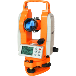
There are two different kinds of theodolites: digital and non digital. Non digital theodolites are rarely used anymore. Digital theodolites consist of a telescope that is mounted on a base, as well as an electronic readout screen that is used to display horizontal and vertical angles. Digital theodolites are convenient because the digital readouts take the place of traditional graduated circles and this creates more accurate readings.
Parts of a Theodolite
Like other leveling instruments, a theodolite consists of a telescope mounted on a base. The telescope has a sight on the top of it that is used to align the target. The instrument has a focusing knob that is used to make the object clear. The telescope contains an eyepiece that the user looks through to find the target being sighted. An objective lens is also located on the telescope, but is on the opposite end as the eyepiece. The objective lens is used to sight the object, and with the help of the mirrors inside the telescope, allows the object to be magnified. The theodolite's base is threaded for easy mounting on a tripod.
How Does a Theodolite Work?
A theodolite works by combining optical plummets (or plumb bobs), a spirit (bubble level), and graduated circles to find vertical and horizontal angles in surveying. An optical plummet ensures the theodolite is placed as close to exactly vertical above the survey point. The internal spirit level makes sure the device is level to to the horizon. The graduated circles, one vertical and one horizontal, allow the user to actually survey for angles.
How to Use a Theodolite

- Mark the point at which the theodolite will be set up with a surveyor’s nail or a stake. This point is the basis for measuring angles and distances.
- Set up the tripod. Make sure the height of the tripod allows the instrument (the theodolite) to be eye-level. The centered hole of the mounting plate should be over the nail or stake.
- Drive the tripod legs into the ground using the brackets on the sides of each leg.
- Mount the theodolite by placing it atop the tripod, and screw it in place with the mounting knob.
- Measure the height between the ground and the instrument. This will be used a reference to other stations.
- Level the theodolite by adjusting the tripod legs and using the bulls-eye level. You can make slight tunings with the leveling knobs to get it just right.
- Adjust the small sight (the vertical plummet) found on the bottom of the theodolite. The vertical plummet allows you to do ensure the instrument remains over the nail or stake. Adjust the plummet using the knobs on the bottom.
- Aim the crosshairs in the main scope at the point to be measured. Use the locking knobs on the side of the theodolite to keep it aimed on the point. Record the horizontal and vertical angles using the viewing scope found on the theodolite’s side.
Theodolite vs Transit Level
A theodolite is a precision instrument used for measuring angles both horizontally and vertically. Theodolites can rotate along their horizontal axis as well as their vertical axis. Theodolites have a lot in common with transits.
A transit is a surveying instrument that also takes accurate angular measurements. Along with the transit, theodolites have mounted telescopes that can be rotated in different directions. Both theodolites and transits can be used for similar projects, but there are slight differences between the two instruments. Transits use vernier scales and external graduated metal circles for angular readings. Theodolites use enclosed graduated circles and angular readings are taken using an internal magnifying optical system. Theodolites tend to have a more precise reading and provide greater accuracy in measuring angles than transits do.
Theodolites are mainly used for surveying, but they are also useful in these applications:
- Navigating
- Meteorology
- Laying out building corners and lines
- Measuring and laying out angles and straight lines
- Aligning wood frame walls
- Forming panels
- Plumbing a column or building corner
Advantages of Using a Theodolite
Theodolites have many advantages when compared to other leveling instruments:
- Greater accuracy.
- Internal magnifying optical system.
- Electronic readings.
- Horizontal circles can be instantly zeroed or set to any other value.
- Horizontal circle readings can be taken either to the left or right of zero.
- Repeat readings are unnecessary.
Theodolites have an internal optical device that makes reading circles much more accurate than other instruments. Also, because the theodolite allows you to take fewer repeat readings, these measurements can be made much more quickly. Theodolites with optical instruments have advantages over other layout tools. They have more precise measurements, they are unaffected by wind or other weather factors, and they can be used on both flat ground and sloped ground.
Caring For a Digital Theodolite and Helpful Hints
Like other instruments, theodolites require proper care and maintenance to ensure the best results and reduce wear and tear on the instrument.
- Do not submerge instrument in water or any other chemical.
- Do not drop instrument.
- Make sure theodolite is locked in its case while transporting.
- When raining, use cover over instrument.
- Do not look directly into the sunlight through the telescope on the instrument.
- Using a wooden tripod can protect the instrument from vibrations better than an aluminum tripod would.
- Using the sunshade attachment is important; any sudden temperature changes can cause incorrect readings.
- Never hold the instrument by the telescope.
- Always have a substantial level of battery power on your instrument.
- Always clean the instrument after using.
- Dust in the case or on the instrument can cause damage.
- If the theodolite is damp or wet, allow it time to dry out before storing it in its case.
- When storing, make sure that the telescope on the instrument is in the vertical position.
- When the theodolite is being re-leveled, the position over the ground point must be checked and rechecked to ensure the same position.
- When the theodolite is being repositioned over a ground point, the level must be checked and rechecked to ensure its accuracy.
Sunday, 26 May 2024
Laser Level v Theodolite
Monday, 13 January 2014
Smartphones Open Up Science to Everyone
Sunday, 12 January 2014
The GPM team has made up the time lost due to weather delays
Global Precipitation Measurement (GPM) is an international satellite mission to provide next-generation observations of rain and snow worldwide every three hours. NASA and the Japanese Aerospace Exploration Agency (JAXA) will launch a “Core” satellite carrying advanced instruments that will set a new standard for precipitation measurements from space. The data they provide will be used to unify precipitation measurements made by an international network of partner satellites to quantify when, where, and how much it rains or snows around the world.
The GPM mission will help advance our understanding of Earth's water and energy cycles, improve the forecasting of extreme events that cause natural disasters, and extend current capabilities of using satellite precipitation information to directly benefit society. The GPM Core Observatory is currently being built at NASA Goddard Space Flight Center in Greenbelt, Md., which is home to a Class 10,000 High Bay Cleanroom.
For the test, small cubes are placed at each part that needs checking and an instrument called a theodolite, similar to a surveyor's instrument, makes exact measurements. Measurements are taken in both the horizontal and vertical orientations of the spacecraft, in order to "see" each cube, and were completed as expected with no problems.
In addition, the GPM team has made up the time lost due to weather delays during the satellite shipment in November. They are currently on schedule for the remainder of testing, which continues with a check of the propulsion system. The GPM Core Observatory is scheduled for launch from JAXA’s Tanegashima Space Center between 1:07 p.m. and 3:07 p.m. EST on Thursday, Feb. 27 (3:07 a.m. to 5:07 a.m. Japan Standard Time on Friday, Feb. 28).
Tuesday, 24 September 2013
Why Sygic India Released Its GPS Android App For Free
Sygic’s maps are powered by MapmyIndia, an Indian location based mapping service. The company claims that it provides navigation in 115 countries with integrated data from travel and mapping companies such as TomTom and TripAdvisor. Some of the features included in the Sygic navigation app are turn by turn voice guided GPS navigation, 3D cities and languages, voice guidance in more than 40 languages, multi stop routes and drag & drop route editing, speed limit display and audio warning, road incident sharing with other drivers, SOS/help to find assistance, spoken street names in American and British English, Interative maps, POI, pedestrian navigation and stopwatch for outdoor activities.
An article by TechCrunch hints that poor sales in India resulted in this price drop. Sygic CEO Michael Stencl told the publication they reported daily sales of only around $250, which is about a sixth of its US app sales. Credit card penetration is India is extremely low making it difficult for developers to monetize their apps. Note that Google Play Store only allows users to make a payment through credit card. We wonder why Google hasn’t rolled out carrier billing on the Play Store, since it has already tied up with RCOM and Uninor.
Besides this, users also use Google Maps on their device for their mapping needs, which are quite good and a default mapping service on their device.The only reason it fails is because of offline navigation features, which apps like Sygic can capitalize on.
Sygic’s navigation competes with mapping services such as Google Maps, Nokia owned maps and location service company NAVTEQ, TomTom, among others. Tom Tom’s Android navigation app for India is priced at Rs 2,050. Google offers it’s navigation app for free and had recently acquired an Israeli location based service startup Waze for an undisclosed amount, adding real time traffic information to its app.
In September 2012, Virbisol, an IT consulting company, had launched Traffic Genie, an app on Android and iOS platform that updates real time traffic information in Bangalore. Nokia Navigation also recently extended real time traffic updates on web based maps to mobile maps and navigation app, Nokia Drive, on its Symbian and Windows Phone smartphones. Apart from that MapMyIndia also provides real time traffic updates in select few places.
Sunday, 22 September 2013
the Protestant Protest put Ballymoney into the press headlines across the United Kingdom
“In the early 20th century the political lines in Ulster were clearly defined,” writes Beattie in the foreword to an account of the enigmatic ‘Protestant Protest’ of 1913. There were the two sides in the well-known argument, outlined in Beattie’s foreword as “the Unionists, from Protestant Communities, (who) vehemently resisted Home Rule; against them were Roman Catholic Nationalists who were growing increasingly impatient to see an Irish Parliament in Dublin.”
The title of the book about the Town Hall protest, published by Ballymoney’s Ullans Centre, puts North Antrim’s curious revolt in context, calling it A Ripple in the Pond.
The event organisers hoped it would be the beginning of a major thrust for Home Rule and some described it as a ‘grand success’. Other contemporary commentators termed it ‘a political illusion’. The Presbyterian weekly publication The Witness stated ‘the hum of a corner (the Route) is not the buzz of a province.’ A later counter-demonstration proclaimed the Protestant Home Rulers as ‘rare birds’.
There are a variety views and differing analysis of what went before, during, and after the Town Hall gathering but two elements of the historic narrative are for sure - it was part of a liberal Protestant movement which condemned the stance taken by the Unionist establishment, and it was packed with drama!
The organisers argued about and questioned each others’ motives, insults flew, tempers frayed, plans and strategies were won and lost, Roger Casement was hounded by besotted lover Ada McNeill, and there were (unfounded) rumours of a plot to disrupt the meeting by ‘a band of Orange rowdies to drown the speakers.’
Historian J.R.B McMinn describes the event questioningly as “a Nationalist mirage?” adding “it was to be the final manifestation of the North Antrim constituency’s Protestant liberal tradition before the outbreak of the First World War.”
Locally the gathering will always be linked to Rev J.B. Armour, but it seems to have been devised and instigated by Captain Jack White D.S.O. though records reveal that Sir Roger Casement “appears to have had much the same idea”, claims J.R.B. McMinn, describing both men as “incurable romantics” in their different ways.
McMinn reckons they chose Ballymoney as the venue “largely because of its traditional reputation as a centre of radical, anti-Unionist politics.” Guest speakers Casement, White and Alice Stopford Green were on the Town Hall stage along with over 30 other like-minded stalwarts.
It was a hugely colourful platform party! Broughshane-born Boer War hero Captain White was married to a half-Spanish Roman Catholic wife, despite opposition from both their families.
“With my bible and shillelagh,” White stated “I went to the Route to chase the most elusive of all hares, the spirit of ’98.”
McMinn’s description of the Captain proposes an enigmatic character who knew little of Irish history or politics - an “ex-soldier, ex-tramp, ex-lumberjack, a devotee of Bergeson and Marx, fresh from a Tolstoyan community in Gloucester…”
Rev J.B Armour and another of the speakers, Dr. Thomas Taggart, both had their qualms about White who confidently expected them “to respond to the predestined something I felt in myself.” According to Armour, who considered White to be (at least) ‘peculiar’, Roger Casement had suggested a similar kind of meeting as the Captain and his newly formed committee was organising.
McMinn recounts that Casement “hoped, with the assistance of every drop of fenian blood ‘in my soul’ to ‘light a fire’ which would ‘set the Antrim hills ablaze’ and would ‘unite (for I think it is possible) Presbyterian and Catholic farmers and townsmen at Ballymoney in a clear message to Ireland’”
Armour and White countered Casement’s ‘Irish-Ireland’ agenda by limiting the meeting to Protestants, trumpeting their essential message that not all Protestants supported Carson.
The path to the Protestant Protest was a rocky one, cobbled with behind-the-scenes controversy, debate and disagreement, but ultimately the veteran Ballymoney Protestant Liberal John McElderry agreed to preside over the proceedings and a cast of speakers was decided.
The event was considered to be something of a security risk and the authorities were fearful for the safety of the speakers and the attendees. Ticket holders only were allowed entrance to the Town Hall. It was reported that 80 additional police were drafted in, but there were no disturbances.
An amusing side-show transpired when two unsuspecting land surveyors arrived in the town centre with their theodolite and tripod on their car’s back seat. “In the darkness the police mistook their theodolite and levelling staff for a dismantled Maxim Nordenfeldt gun,” quotes McMinn. The police were just about to arrest the two surveyors “when the mistake was realised.”
Across the road, “the interior of the Town Hall was (very significantly) decorated with Union Jacks and other flags. Over the platform was a large panel inscribed ‘No provisional or provincial government for us.’”
The speakers pledged lawful opposition to Carson’s Unionism and called for the government to bring “all Irishmen together in one common field of national effort.”
The complete “almost verbatim report of the principle speeches” was later recorded in a hefty one-penny pamphlet entitled ‘A Protestant Protest’. Most commentators agree that “the speeches were based on romantic ideals rather than political reality.”
The event began with a resolution setting out the organisers’ objectives which “far from proclaiming a Republic,” most commentators recount “called upon the Government of Britain to intervene and take action against Carson and the anti-Home rule movement.”
Captain White then attempted to explain why so many Protestants were opposed to Home Rule, with pro-Home Rule historian and Meath-born Anglican Alice Stopford Green giving a similar address “with a message of ecumenical exhortation to her fellow Protestants” surmises the book A Ripple in the Pond “playing down the feared influence of the Roman Catholic Church and reminding her co-religionists who, in her eyes, the real enemy was.”
Captain White contended that “the Protestants of Ulster are afraid of Rome Rule, (with) undue preference given to Catholics and interference in politics and in education on the part of the priests. Were it not for that fear there is not a man in this hall tonight but knows that the opposition to Home Rule here in the North would collapse through want of fuel. But I propose to show,” continued the Captain “throughout the past there has never been a…demand for a free and united Ireland, but the authority of Rome opposed it or gave it a tardy and reluctant support.”
Stopford Green reminded the audience how co-operation and unity of purpose between Presbyterians and Roman Catholics had been achieved in the past. “Never has there been in Ireland a persecution of Protestants for religion’s sake,” she stressed, adding that the Presbyterians “have been the Church of the people, not of the aristocracy or of a political hierarchy. They have suffered with the Irish people,” she stated, “and stood by them in the old days. They have nobly shown the virtues that spring from a true democracy and high human fellowship.”
This theme continued throughout all of the speeches, seemingly a re-assural to Protestants rather than a stamp of approval on Home Rule.
“Certainly, all of those who addressed the meeting were in favour of Home Rule,” observes the book A Ripple in the Pond, “but all for different reasons.”
Casement was the third speaker, undaunted by the presence in the audience of his unrequited lover Ada McNeill. He continued the previous speakers’ themes of reconciliation, stressing the need to look to Ireland’s past. He argued that politics were as important as “the welfare of the common country of Ireland.”
Casement strongly maintained that the exclusion of Ulster would not be a solution to the Home Rule crisis. “We want Ulster for Ireland and Ireland for Ulster,” he concluded dramatically. The gathering ended with everyone singing the National Anthem.
Despite Casement’s intentions, the Protestant Protest did not “set the Antrim hills ablaze”, and no further meetings took place. In contrast, an anti-Home Rule meeting was held in the same building a month later and the surrounding streets were apparently packed with crowds.
Local historian Alex Blair notes that the Protestant Protest “put Ballymoney into the press headlines across the United Kingdom. All the big London papers had a representative in the Town Hall and The London Times carried an editorial as well as a report.” The lack of support for the cause showed that Protestant Home Rulers were, as one journalist of the time wrote, ‘rare birds’.
Sunday, 7 August 2011
Land surveyors needed for yacht measurement
The hull file is a 3D model collected using a reflector-less total station; the model is used in the ORC Manager 2 software in conjunction with data from in water tests of the boat’s righting moment and measurement of the rig and sails to produce a detailed rating.
Measurement of a boat’s hull typically takes one day on the hardstand, but needs some preparation and follow up data editing to complete the entire hull measurement process.
Ian Souter, land surveyor and Sydney-based sailor, is currently assisting Yachting Australia with measurement.
“The measurement process is pretty simple for someone who has the gear, can operate a theodolite, and has an understanding of either dinghy class measurement, or rating systems,” he said. “Now that we’ve done a couple of complete hull measurements, and with my background as an International 420 class measurer, it’s an easy enough task for us.”
In-water testing, such as inclining and measurement of the freeboards, rig and sails required by ORCi, are a separate process undertaken by a Yachting Australia appointed Measurer and can be done at any other time.
So that it can maintain its capacity to service this area of the sport, Yachting Australia is looking to increase its network of people who have the appropriate skills and experience to measure hulls for ORCi.
Land surveyors with access to a reflector-less total station and sundry surveying equipment, who also have a strong background in ocean racing, rating systems or class measurement, can contact Glen Stanaway at Yachting Australia by emailing glen.stanaway@yachting.org.au or by phoning 02 8424 7408.
Priority areas for Yachting Australia are Adelaide, Melbourne and Perth, with boats currently awaiting opportunity to be measured. Yachting Australia would like to hear from interested land surveyors in these cities as soon as possible.
Details about ORCi can be found at: www.yachting.org.au/orc and www.orc.org/
Monday, 28 March 2011
Hunter Research and Technology is pleased to show Theodolite app for iPad 2
- Hunter Research and Technology today is pleased to announce that its popular Theodolite app series is now available in a special new version for iPad 2. Theodolite HD is a viewfinder-based compass, GPS, map, zoom camera, rangefinder, and two-axis inclinometer. The app looks to repeat the success it has had on iPhone, becoming the #1 selling paid navigation app in the US iTunes store in December 2009 and September 2010. Theodolite has been featured numerous times in iTunes, including “Rewind 2010: Hot Trends in Apps” and “Augmented Reality: The World Around You”.
The new flagship of the Theodolite series, Theodolite HD includes features for serious users such as a zero reference angle mode, an A-B calculator for height, distance, heading, position, triangulation, and relative angles, a built-in map with standard, satellite, and hybrid views, two mil-based rangefinders, colored lens filters to improve use in dark conditions and preserve night vision, e-mail export with KML data, system-wide clipboard integration, percent grade display, optical rangefinders, military grid reference system (MGRS) coordinates, universal transverse Mercator (UTM) coordinates, and four latitude/longitude formats.
The software implements an advanced “fusion” algorithm that combines gyro and magnetometer data to provide a more accurate, more responsive, and more robust compass measurement. Theodolite is able to provide stable compass bearing to any landmarks visible in the camera viewfinder, regardless of how the user holds or points the device. This provides a significant increase in utility over traditional palm held compasses and compass apps.
Device Requirements:
* iPad 2 Wi-Fi and iPad 2 Wi-Fi + 3G
* Requires iOS 4.3 or later
* 3.8 MB
Pricing and Availability:
Theodolite HD 2.4 is available for $3.99 on the iTunes App Store and works on all versions of the iPad 2. Users with iPhones and 4th-generation iPod touch devices can check out the Theodolite Free, Basic, and Pro apps for free, $1.99, and $3.99, respectively. More information, including screenshots, is available on the Hunter Research and Technology website. Media professionals interested in reviewing Theodolite HD can request a promotional code to download the app from iTunes at no cost.
Tuesday, 15 February 2011
Hunter Research and Technology today is pleased to announce the release of Theodolite 2.3 on the iTunes
Based on the concept of a centuries-old astronomical instrument, Theodolite overlays real-time information about position, altitude, bearing, range, and horizontal/vertical inclination on the iPhone’s live camera image, turning the iPhone into a sophisticated electronic viewfinder. Theodolite lets users take geo-stamped and geo-tagged camera images directly from the app, with 2X and 4X digital zoom options, and contains a built-in map with standard, satellite, and hybrid views. Uses are endless, and the app is great for navigation, outdoor sports, home projects, and photography. Theodolite is used in the field by surveyors, geologists, avalanche researchers, military personnel, and search and rescue workers around the world.
Theodolite comes in three versions – Free, Basic, and Pro – to cover a range of customer needs. The flagship Theodolite Pro includes features for serious users, such as a zero reference angle mode, an A-B calculator for height, distance, heading, position, triangulation, and relative angles, e-mail export with KML data, system-wide clipboard integration, percent grade display, optical rangefinders, military grid reference system (MGRS) coordinates, universal transverse Mercator (UTM) coordinates, and four latitude/longitude formats.
Version 2.3 of Theodolite implements performance improvements for smoother rendering, lower CPU usage, and a reduction in overall memory usage. The app also sports a refined UI look and feel. Basic and Pro versions of the app now take high res 960×640 screenshots on devices with a Retina display and include a faster photography engine with buffered image saves. Theodolite Pro adds colored lens filters to improve use in dark conditions and preserve night vision, a recalibration of optical rangefinders with proper lens specs on all devices, and an additional mil-based rangefinder. With these new capabilities, Theodolite continues its role as a technology demonstrator app, showcasing the latest and greatest in iOS hardware and software capabilities.
Pricing and Availability:
As the name suggests, the demo version “Theodolite Free” is available for free on the iTunes App Store. The mid level “Theodolite Basic” costs $1.99 (USD), and the full-featured “Theodolite Pro” is $3.99. Theodolite runs on any iPhone with iOS 4.1 or later and also works on the new 4th generation iPod touch. More information, including screenshots, is available on the Hunter Research and Technology website. Media professionals interested in reviewing Theodolite can request a promotional code to download the apps from iTunes at no cost.
Wednesday, 9 February 2011
Nikon NE-103 Series electronic digital theodolites from TDS
Sunday, 30 January 2011
Museum acquires artifacts of tragic polar expedition by theodolite
Museum officials recently acquired the artifacts from a descendant of the late Charles Wright, the Toronto man who found the bodies of Scott and his comrades after they perished on their return from the Pole a century ago.
One of the instruments, a theodolite, is the navigation tool that helped Wright plot a route across the icy expanses of Antarctica to eventually locate the dead bodies of Scott and his companions frozen inside their snow-shrouded tent.
The other is a roughly crafted sundial given to Wright as a memento on the Beardmore Glacier by the expedition’s chief scientist, Edward Wilson, in December 1911. “Uncle Bill” Wilson was among those who died with Scott, pinned for days at their last camp by a ferocious storm.
The artifacts were originally among a treasure trove of Wright’s Antarctic memorabilia, most of which was sold piecemeal last Sept. 22 in London, England, by the Christie’s auction house.
But the Canadian Cultural Property Export Review Board refused to let the theodolite and sundial out of the country, citing the “significance of their association with the Scott expedition and with a Canadian scientist recognized in his own right.”
The federal body is a watchdog that keeps important cultural artifacts in Canada.
The Canada Science and Technology Museum then made a successful offer to Adrian Raeside, Wright’s grandson, and the two relics of Antarctica’s golden age of exploration will soon go on public display in Ottawa.
The review board also refused Christie’s an export permit for Wright’s box camera, and it was purchased in Canada last fall for $21,600 by an unidentified buyer believed to reside in British Columbia.
Wright’s medals and decorations, also restricted to Canada, were sold for more than $96,000 to a mystery bidder.
Science museum officials said they cannot disclose what they paid for the theodolite and sundial, under rules that protect the seller’s privacy.
Raeside, a well-established editorial cartoonist living in Whistler, B.C., recently wrote a book about his grandfather after visiting some of the Antarctic locales of Scott’s expedition. He is also working on a film.
Scott’s adventure in the south is one of the best-loved tales of exploration, even though he died on the return journey from the Pole and was beaten to the prize by upstart Norwegian explorer Roald Amundsen more than a month earlier. The British team found Amundsen’s tent at the Pole with letters awaiting them inside.
But the full story of Scott’s death march might never have been told had Wright not spotted a speck of dark material slightly off the trail of the search party. Inspecting it, he found a snow-covered tent with the frozen bodies of Scott and two other men. Also inside were Scott’s now-famous diaries that told the horrid tale — diaries that have never been out of print since.
That contrasts sharply with another famous polar expedition that also ended in tragedy. Sir John Franklin died in Canada’s Arctic in 1847 after his two ships failed to find a northwest passage through the thick Arctic ice.
Dozens of rescue ships were dispatched to locate him, but none ever did and the full story of his demise remains a mystery even today. Franklin’s grave has never been found.
The science museum plans to display the Wright objects in the next few weeks as part of its current Franklin exhibition, “Echoes in the Ice: History, Mystery, and Frozen Corpses,” which ends March 20.
The theodolite is a telescope-like instrument made of brass and platinum, its dials and eyepiece covered with soft Chamois leather to protect fingers and eyes in the bitter Antarctic cold. One of six built in 1910 for Scott’s expedition by T. Cooke and Sons Ltd., an English manufacturer based in York, the precision device was assigned to Wright for his fieldwork as a glaciologist and navigator.
The rough sundial was crafted at Scott’s base hut by motor engineer Bernard Day, likely using plywood from a packing case. Designed specifically for use in high latitudes, it is accurate to within about 15 minutes but was not for most science work, which relied on much more precise chronometers.
Senior museum official Randall Brooks says the two objects are a highlight of his career, ranking alongside artifacts belonging to Canadian Nobel-prize winning scientists John Polanyi and Gerhard Herzberg.
“The sundial is quite unusual and was designed specifically for use at high latitudes where the sun rotates around the sky during the summer without setting,” said Brooks, vice-president of collection and research. “I’ve never seen one like it.”
The remainder of Wright’s Antarctic possessions appear now to be scattered around the globe. Daughter Pat Wright sold her father’s diaries to the Scott Polar Research Institute in Cambridge, England, for 12,000 pounds in 1988. And some of the material from last September’s Christie’s auction — including photographs and a pair of skis — was sent as far afield as New Zealand.
Scott was a heroic figure for decades after his death, inspiring a feature film, a symphony by Ralph Vaughan Williams and a spate of memoirs. His standing has diminished since the 1980s, though, as polar historians began to question his preparations and stiff leadership style.
Wright, who died 1975 in retirement on Salt Spring Island, B.C., spent the rest of a brilliant scientific career in Britain helping to develop early radio and radar. Reticent all his life about his south-polar experiences, his diaries and memoirs reveal a deep resentment that Scott had not properly provisioned his hard-working field parties.
Wright, knighted in 1946, believed trail rations were far too small, and half-starved men pulling heavy sledges readily succumbed to the cold and bad weather.
Thursday, 9 December 2010
Theodolite runs on any iPhone with iOS 4.1 or later and also works on the new 4th generation iPod touch
Hunter Research and Technology today is pleased to announce the release of Theodolite 2.2 on the iTunes App Store. This novel multi-function augmented reality viewfinder app serves as a compass, GPS, map, zoom camera, rangefinder, and two-axis inclinometer. Theodolite became the #1 selling navigation app in the US App Store in December 2009 and September 2010.
Based on the concept of a centuries-old astronomical instrument, Theodolite overlays real-time information about position, altitude, bearing, range, and horizontal/vertical inclination on the iPhone's live camera image, turning the iPhone into a sophisticated electronic viewfinder. Theodolite lets users take geo-stamped camera images directly from the app with 2X and 4X digital zoom options, and contains a built-in map with standard, satellite, and hybrid views. Uses are endless, and the app is great for navigation, outdoor sports, home projects, and photography. Theodolite is used in the field by surveyors, geologists, architects, engineers, military personnel, competitive sportsmen, and search and rescue workers around the world.
Theodolite comes in three versions - Free, Basic, and Pro - to cover a range of customer needs. The flagship Theodolite Pro includes features for serious users, such as a zero reference angle mode, an A-B calculator for height, distance, heading, position, triangulation, and relative angles, e-mail export with KML data, system-wide clipboard integration, percent grade display, optical rangefinders, military grid reference system (MGRS) coordinates, universal transverse Mercator (UTM) coordinates, and four latitude/longitude formats.
Version 2.2 of Theodolite adds enhanced photo geo-tagging features long requested by users. These features were finally made possible by recent iOS 4.1 and 4.2 updates. In addition to stamping geographical data on photos and screenshots as an overlay, Theodolite now writes geographical metadata into the image's EXIF header. This allows geo-tag aware applications, mapping tools, and image processing utilities to read this metadata from Theodolite photos and screenshots and use it for a variety of purposes. Metadata written into images by Theodolite includes latitude, longitude, altitude, bearing, map datum, compass convention (magnetic or true), and optional user notes.
With these new capabilities, Theodolite continues its role as a technology demonstrator app, showcasing the latest and greatest in iOS hardware and software capabilities. Version 2.2 also brings along new icon artwork, to better emphasize the app's augmented reality viewfinder features.
Theodolite runs on any iPhone with iOS 4.1 or later and also works on the new 4th generation iPod touch. On iPhone 4, the software implements an advanced "fusion" algorithm that combines gyro and magnetometer data. This fusion approach provides a more accurate, more responsive, and more robust compass measurement that automatically corrects for gyro drift and minimizes effects of magnetic interference. By simultaneously using the iPhone 4's three-axis gyro and three-component magnetometer, Theodolite is able to provide stable compass bearing to any landmarks visible in the camera viewfinder, regardless of how the user holds or points the device. This provides a significant increase in utility over traditional palm held compasses and compass apps.
Pricing and Availability:
As the name suggests, the demo version "Theodolite Free" is available for free on the iTunes App Store. The mid level "Theodolite Basic" costs $1.99, and the full featured "Theodolite Pro" is $3.99. More information, including screenshots, is available on the Hunter Research and Technology website. Media professionals interested in reviewing Theodolite can request a promotional code to download the apps from iTunes at no cost.
Thursday, 25 November 2010
iPhone applications for winter
The North Face Snow Report
Since its launch last year, North Face’s free Snow Report has widely become the go-to app for conditions, with a mix of social media so users can see what others are saying about snowfall totals and other resort-related news with the built-in Twitter feature. The link to a resort’s webcam provides an instant look at the mountain, and mapping technology allows the user a hassle-free location feature. For backcountry enthusiasts, North Face this year released the free Trailhead, an app that finds trails and hikes based on your location and tracks your speed, distance, and elevation with GPS (Global Positioning System).
Ski and Snow Report
While not quite as dynamic as North Face’s version, the free Ski and Snow Report from Skireport.com tends to load a lot quicker. The app allows you to search and save your favorite resorts for easy access. Each resort report contains first-hand accounts and photos from others, both of which are nice resources, especially if you don’t always buy the resort’s ballooned snow report.
OnTheSnow Gear Guide
Thanks to OnTheSnow’s comprehensive app, prospective equipment buyers can head to their retail shop with all the information they need. The Gear Guide features detailed information on more than 230 pieces of ski and snowboard gear. Get reviews, pricing, and technical specifications, all of which you can compare against other products.
RealSki
Like a technological window, RealSki utilizes augmented reality technology to provide enhanced details about one’s surroundings. The free application, which requires a minimum of 3GS on the iPhone, will label trails, chairlifts, and other resort amenities simply by holding your phone as if you were going to snap a photo. Data pertaining to your immediate location will pop up on the screen, providing a precise way to determine locale. The technology can’t be used everywhere, but a handful of New England resorts are RealSki-ready, including Sunday River, Stowe, Jay Peak, and Loon.
Theodolite
Diving a little deeper into augmented reality technology is Theodolite, which displays real-time information about altitude, position, and inclination. If lost in the backcountry, it could provide a valuable tool for navigating back to civilization, provided you have a signal, of course. Three versions are available: Free, Basic ($1.99), and Pro ($3.99).
ITrailMap
The days of fumbling with a map on a windy lift ride are over. ITrailMap compiles the official maps for more than 650 resorts worldwide into one convenient app. While the free version allows the ability to download and store maps, iTrailMap 3D ($4.99) goes a step further, combining the traditional maps with GPS and 3-D technology, allowing you to track your vertical and distance skied, and upload those stats to Google Earth.
The Weather Channel
No weather app delivers so much simplicity with so many options. The Weather Channel remains the gold standard for pinpointing outdoor plans with its ease of use and the ability to transition between stored locations instantly, a tool that allows skiers and riders to try to discover which area is forecast to get more snow on any given day. The free version also includes animated radar and regionalized video forecasts. Upgrade to The Weather Channel Max ($3.99), and you’ll also receive traffic cameras and customizable maps.
Adaptunes
Whether you should be cruising down the mountain with your earbuds in is probably arguable. But in any case, the 99-cent Adaptunes will make sure you hear the music over the wind with an app that automatically adjusts your volume based on speed. Simply select the sort of activity you’re performing and volume control will be based on your movements.
Backcountry
For those thinking about getting into the backcountry experience, Backcountry provides invaluable tools for the novice. Find hikes in your area, including a GPS-led guide leading you to your start point, as well as tips and a checklist for venturing out into the mountains. Free.
Tapped
A handful of New England resorts — Sunday River, Okemo, Smuggler’s Notch, and Stratton — host Tapped, a free app that allows you to locate yourself with GPS on each resort’s specific trail map. You will also have the ability to locate family members and friends with a sharing function, locate key resources at the mountain, get up-to-the-minute resort information including snowfall and lift status, and record your tracks and log your vertical for the day.
Steep and Cheap
A longtime favorite online retailer for outdoor enthusiasts, Steep and Cheap released its first app this year, providing some of the best deals available. If you have used Steep and Cheap, it’s the same deal with the free app, one item at a time for sale for a limited amount of time, or until supply runs out.
Skullcandy
Outdoor action sports retailer Skullcandy gets into the mobile business with its free 3-in-1 app, providing the latest weather and conditions related to surfing, skating, and skiing and riding. Additionally, you will be able to stream music from over 50 artists, and watch action sports videos created by the Skullcandy team. Due to some mature material, this app is recommended for those over age 12.
Monday, 8 November 2010
Lessons from an Awalkhed school
With some parts of the country receiving heavy rainfall, while others getting less than normal rain, there is lower productivity, crop loss and agricultural distress. This state of affairs need not always be the case. One can harvest rain water and make sure that it percolates into the soil and replenishes ground water.
Aseema Educational Trust, an NGO working for the upliftment of tribal children, is running a primary school for the tribal children in Awalkhed village, Igatpuri taluk, Nasik district of Maharashtra. This school has made efforts to conserve water on its 14-acre campus. In spite of receiving an annual average rainfall of 3000-3500 mm in this village, there is an acute shortage of drinking water during the summer. The village was reeling under water crisis. A simple exercise on the school campus worked wonders for the community.
Aseema, with sought guidance from Raghavendra Rao, a consultant and an expert on organic agriculture and ecosystem development, took up the task of conservation of water on their school campus. The campus has an open well which fulfilled the drinking water needs of the communities around. It was important to keep the well recharged at all times.
The intention of the consultant was to demonstrate how plentiful rain water could be conserved through the summer to sustain both the well for drinking and the fields for agriculture, was translated into this. This was done in hope that the villagers could adopt these practices for water conservation in their own lands.
The entire plot was surveyed by Raghavendra Rao and a comprehensive rain-water harvesting plan was drawn up. Raghavendra says, “this was done by walking around and deciding on appropriate places where run-off rainwater could be harvested.” Since the topography is undulating and the hill sides are steep, contour lines were marked using a theodolite, a measuring instrument, and trenches were dug along them. He adds, “the bunding was done starting from the ridge to the valley. This ensured that the rainwater was harvested where it fell, and the run-off, if any, did not acquire erosive force to wash the top soil away.”
In the valleys between the hillocks, a series of check dams were constructed to slow down the run-off water and give it a chance to infiltrate into the ground.
Ecologically self-sustaining system
Once the earthwork was completed and physical structures were constructed, the task of planting a diversity of fast-growing nitrogen-fixing and multi-purpose tree, shrub and herb species was undertaken so as to make the entire area a self-sustaining ecological system producing food, fruit, fibre, fertiliser and fuel wood was undertaken. Species like mango, guava, jackfruit, jamun, sapota, fig, ber, etc were planted to transform the patch into a fruit orchard. Soon, a small area of the flat land will be turned in to a green patch of diverse vegetables, cereals and pulses. This will ensure nutritious food for the children. Besides, the children get to know a thing or two about farming and water conservation practices.
Raghavendra exclaims, “the well is now getting recharged by subterranean streams, when it doesn't rain.” This gets rejuvenated because of the water harvesting work undertaken in the campus. The task has been accomplished in less than two years. As the ecosystem evolves and gets more complex, it will produce a diversity of food, fodder for livestock and serve as a habitat for birds, reptiles and insects.
Raghavendra Rao asserts that similar work can be accomplished in all the vastly degraded areas of our country. A demonstration such as this was accomplished with the participation of the community. This may also have the added effect of encouraging villagers in the surrounding communities to do similar things on their lands. With a little effort one can convert unproductive lands into oases of productivity - a mission for a greener, food and water secure country.
Saturday, 6 November 2010
Newest iTunes Featured with Theodolite Augmented Reality Viewfinder App
Based on the concept of a centuries-old astronomical instrument, Theodolite overlays real-time information about position, altitude, bearing, range, and horizontal/vertical inclination on the iPhone's live camera image, turning the iPhone into a sophisticated electronic viewfinder. Theodolite lets users take geo-stamped camera images directly from the app with 2X and 4X digital zoom options, and contains a built-in map with standard, satellite, and hybrid views. Uses are endless, and the app is great for navigation, outdoor sports, home projects, and photography. Theodolite is used in the field by surveyors, geologists, architects, engineers, military personnel, competitive sportsmen, and search and rescue workers around the world.
Theodolite comes in three versions - Free, Basic, and Pro - to cover a range of customer needs. The flagship Theodolite Pro includes features for serious users, such as a zero reference angle mode, an A-B calculator for height, distance, heading, position, triangulation, and relative angles, e-mail export with KML data, system-wide clipboard integration, percent grade display, optical rangefinders, military grid reference system (MGRS) coordinates, universal transverse Mercator (UTM) coordinates, and four latitude/longitude formats.
Theodolite runs on any iPhone with iOS 4 and also works on the new 4th generation iPod touch. On iPhone 4, the software implements an advanced "fusion" algorithm that combines gyro and magnetometer data. This fusion approach provides a more accurate, more responsive, and more robust compass measurement that automatically corrects for gyro drift and minimizes effects of magnetic interference. By simultaneously using the iPhone 4's three-axis gyro and three-component magnetometer, Theodolite is able to provide stable compass bearing to any landmarks visible in the camera viewfinder, regardless of how the user holds or points the device. This provides a significant increase in utility over traditional palm held compasses and compass apps.
Pricing and Availability:
As the name suggests, the demo version "Theodolite Free" is available for free on the iTunes App Store. The mid level "Theodolite Basic" costs $1.99 (USD), and the full featured "Theodolite Pro" is $3.99. More information, including screenshots, is available on the Hunter Research and Technology website. Media professionals interested in reviewing Theodolite can request a promotional code to download the apps from iTunes at no cost.
Tuesday, 24 August 2010
iTunes has Theodolite 2.0
Williamsburg Virginia – Hunter Research and Technology today announces the immediate worldwide availability of Theodolite 2.0 on the iTunes App Store. This novel multi-function augmented reality app for the iPhone serves as a compass, GPS, map, zoom camera, rangefinder, and two-axis inclinometer. Theodolite became the #1 selling navigation app in the US and UK App Stores in December 2009 after being featured by Apple in the New and Noteworthy category of the iTunes App Store, and broke into the Top 40 Paid Apps ranking in the US and Top 20 in the UK.
Based on the concept of a centuries-old astronomical instrument, Theodolite overlays real-time information about position, altitude, bearing, range, and horizontal/vertical inclination on the iPhone’s live camera image, turning the iPhone into a sophisticated viewfinder. Theodolite lets users take geo-stamped camera images directly from the app with 2X and 4X digital zoom options, and contains a built-in map with standard, satellite, and hybrid views. Uses are endless, and the app is great fornavigation , construction, hiking, boating, hunting, sightseeing, photography, and sports. The app is used in specialty fields by surveyors, geologists, architects, engineers, military personnel, and search and rescue workers around the world.
Theodolite comes in three versions – Free, Basic, and Pro – to cover a range of customer needs. The flagship Theodolite Pro includes features for serious users, such as a zero reference angle mode, an A-B calculator for height, distance, heading, position, triangulation, and relative angles, e-mail export with KML data, system-wide clipboard integration, percent grade display, optical rangefinders, military grid reference system (MGRS) coordinates, universal transverse Mercator (UTM) coordinates, and four latitude/longitude formats.
Version 2.0 of Theodolite adds multitasking support and background task completion for iOS 4, along with revised graphics and a new optical-mechanical calibration. The app now makes use of the iPhone 4 gyro for improved inclinometer measurements, and includes high resolution artwork for the iPhone 4 Retina display. The result is a more accurate, more responsive display with amazing visual fidelity and detail.
“The iPhone 4 is an amazing sensor device, with improved horizontal and vertical GPS accuracy, a more robust magnetometer implementation, an improved 12-bit accelerometer, and a new MEMS gyro”, said Dr. Craig Hunter, Theodolite developer. “Combined with the stunning Retina display and an advanced SDK, it’s an engineer’s dream device that is ideal for augmented reality applications. I’m pleased that Theodolite is continuing its role as a technology demonstrator, showcasing the latest and greatest in iPhone hardware and software capabilities”.
Pricing and Availability:
As the name suggests, the demo version “Theodolite Free” is available for free on the iTunes App Store. The mid level “Theodolite Basic” costs $1.99 (USD), and the full featured “Theodolite Pro” is $3.99. The apps run on iPhones with OS 4.0 or later. GPS functionality requires an iPhone 3G, 3GS, or 4. Compass functionality requires an iPhone 3GS or 4. More information, including screenshots, is available on the Hunter Research and Technology website. Media professionals interested in reviewing Theodolite can request a promotional code to download the apps from iTunes at no cost.
Theodolite 2.0: http://hunter.pairsite.com/theodolite/
Purchase and Download: http://itunes.apple.com/us/app/theodolite-pro/id339393884?mt=8
Media Assets: http://hunter.pairsite.com/pr/
Hunter Research and Technology is run by Dr. Craig Hunter, a practicing engineer with 20 years of experience in mechanical engineering, aerospace engineering, and software development. Craig received the 2004 NASA Software of the Year Award and a 2004 Apple Design Award (Best Scientific Computing Solution on Mac OS X) for his work in softwaredevelopment . Craig founded Hunter Research and Technology in 2008 to create innovative and compelling apps that take advantage of the advanced hardware and software capabilities of iPhone OS devices. The company has 15 apps available on the iTunes App Store, and develops software and apps for a range of clients worldwide. iTunes, iPhone, iPod, and Retina display are registered trademarks of AppleComputer Inc. in the U.S. and/or other countries.